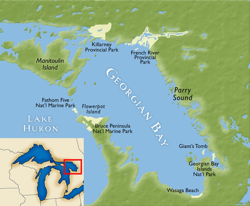
Georgian Bay is about 190 kilometres (120 mi) long by 80 kilometres (50 mi) wide. It covers approximately 15,000 square kilometres (5,800 sq mi), making it nearly 80% the size of Lake Ontario and the fourth largest lake completely within Canada.
Eastern Georgian Bay is part of the southern edge of the Canadian Shield. It features granite bedrock exposed by the glaciers at the end of the last ice age, about 11,000 years ago. The granite rock formations and windswept eastern white pine are characteristic of the islands and much of the shoreline of the bay. The rugged beauty of the area inspired landscapes by artists of the Group of Seven.
It is the essence of cottage country presenting a variety of diverse perspectives and needs, from seasonal and permanent populations to local businesses and tourism industries that serve the cottagers and boaters.
Port Severn is the terminus of the Trent-Severn Waterway and the entrance to the small craft channel that offers protected waters for pleasure craft all the way to Killarney at the north end of the bay. This is the gateway to the world-famous 30,000 Islands and the access point to Georgian Bay Islands National Park.
Midland and Penetanguishene have a number of marinas offering the full range of services, plus access to more urban lifestyles. Parry Sound is a little further north and is the last opportunity to provision before Britt in Byng Inlet or Little Current on Manitoulin Island. Otherwise, communities are smaller and the number of cottages lining the shores start to diminish. Anchorages abound. The water is clear and cold. The fishing is incredible.
Posts from Georgian Bay:
- Very Interesting Day, Weather Wise
- This is Ridiculous
- Over to Penetanguishene
- Second Stop in Midland
- Visitors
- First Stop in Midland
- Launch Day 2022
- Boating Season 2021 is Over
- Some New Bling for Moon Dance
- A Different World
- Victoria Harbour
- Midland
- Honey Harbour
- Georgian Bay National Park
- Parry Sound
- Byng Inlet
- Collins Inlet
- Killarney
